Carrying a novel P-band Synthetic Aperture Radar (SAR), the BIOMASS mission is designed to deliver crucial information about the state of our forests, how they are changing and their quantitative role in the carbon cycle.
The launch
Date: 2023
Site: Kourou, French Guiana
Rocket: Vega
First P-band radar in space / full polarimetry / interferometry and tomography / 666 km altitude / 3-day repeat cycle
1 - The BIOMASS mission
ESA’s forest mission - BIOMASS
ESA’s forest mission, BIOMASS is the first satellite to carry a P-band Synthetic Aperture Radar (SAR), in combination with polarimetric and interferometric capabilities. With an exceptionally large antenna of about 12 m diameter, BIOMASS generates a wavelength 70 cm long. Its radar signal will penetrate through the whole forest layer, seeing the larger elements of the tree (like trunk and branches, constituting a significant amount of biomass) and transparent to canopy leaves. The signal scattered back will therefore carry information about the forest structure that can be used to infer parameters such as forest biomass and forest height. Additionally, the mission will have a specific experimental tomographic phase to provide 3D views of forests.
Forests, especially in the tropics, represent a major sink of carbon dioxide. However, the spatial distribution of forest carbon stocks and related fluxes is not yet well-quantified. Above-ground biomass (AGB) in forests, which contains about 50% of carbon, is a central factor in the carbon budget, but in many parts of the planet AGB is poorly quantified due to the difficulty in collecting sufficient field measurements. Moreover, forest degradation and deforestation are causing release of the stored carbon back into the atmosphere, with negative impact on the ecosystem. Information from the BIOMASS mission will hopefully lead to a better understanding of the state of Earth’s forests, how they are changing over time, which quantitative role they play in the carbon cycle.
2 - Measuring Forests
Mapping forests from space
Measuring the biomass of a tree is not an easy task: unless it is cut and then weighted, its mass can only be inferred indirectly from measurements. In classical forestry, this problem can be solved for instance by measuring the height, diameter of the trunk, wood density and then calculating the mass through allometry. However, in-situ measurements are usually costly and difficult to do in remote areas and thus limited in time and space.
Thanks to the long wavelength of P-band, BIOMASS signal, depending on polarisation, will penetrate through the whole forest layer and scatter back from the bone of the tree (trunk, branches). In this way, information about forest structure can be inferred from space on a global scale.
Compared to previous spaceborne SARs, BIOMASS is the first to offer polarimetry (PolSAR), polarimetric-interferometry (PolInSAR) and tomography (TomoSAR) altogether. Interferometric observations allow for the cancellation of the ground contribution from the signal, giving measurements more correlated to the volume of biomass in the tree. The combination of interferometry and polarimetry is used for the retrieval of forest height, while tomography allows mapping forests in 3D.
In addition, the BIOMASS mission will offer the opportunity to pursue secondary objectives such as the retrieval of sub-canopy Digital Terrain Model (DTM), mapping subsurface geology (theoretically possible in deserts and glaciers), measuring ice-sheets velocity and ionosphere properties.
Launcher: Vega from Europe’s Spaceport in French Guiana
Satellite: Three-axis stabilised platform, 10 m high, 12 m wide and 20 m long (including large antenna)
Mass: 1170 kg (including 67 kg fuel)
Instrument: Fully polarimetric P-band Synthetic Aperture Radar (SAR) instrument operating at 435 MHz frequency
Power: 1.5 kW deployable solar array with 6.8 m2 triple junction GaAs cells; 144 Ah Li-ion battery
Orbit: Sun-synchronous, at altitude of 666 km inclined at 98 degrees, 3-day repeat cycle
Life: Minimum of 5.5 years
Communication: Science data transmitted to Kiruna (Sweden) via X-band downlink. Tracking, telemetry and command transmitted via S-band uplink and downlink
Mission control: ESA’s European Space Operations Centre (ESOC) in Darmstadt (Germany)
Data processing: ESA’s Centre for Earth Observation (ESRIN), in Frascati (Italy)
Scientific objectives: Deliver the first global and systematic measurements of forest height and biomass
Project and commissioning: Managed at ESA’s European Space Research and Technology Centre (ESTEC) in Noordwijk (the Netherlands)
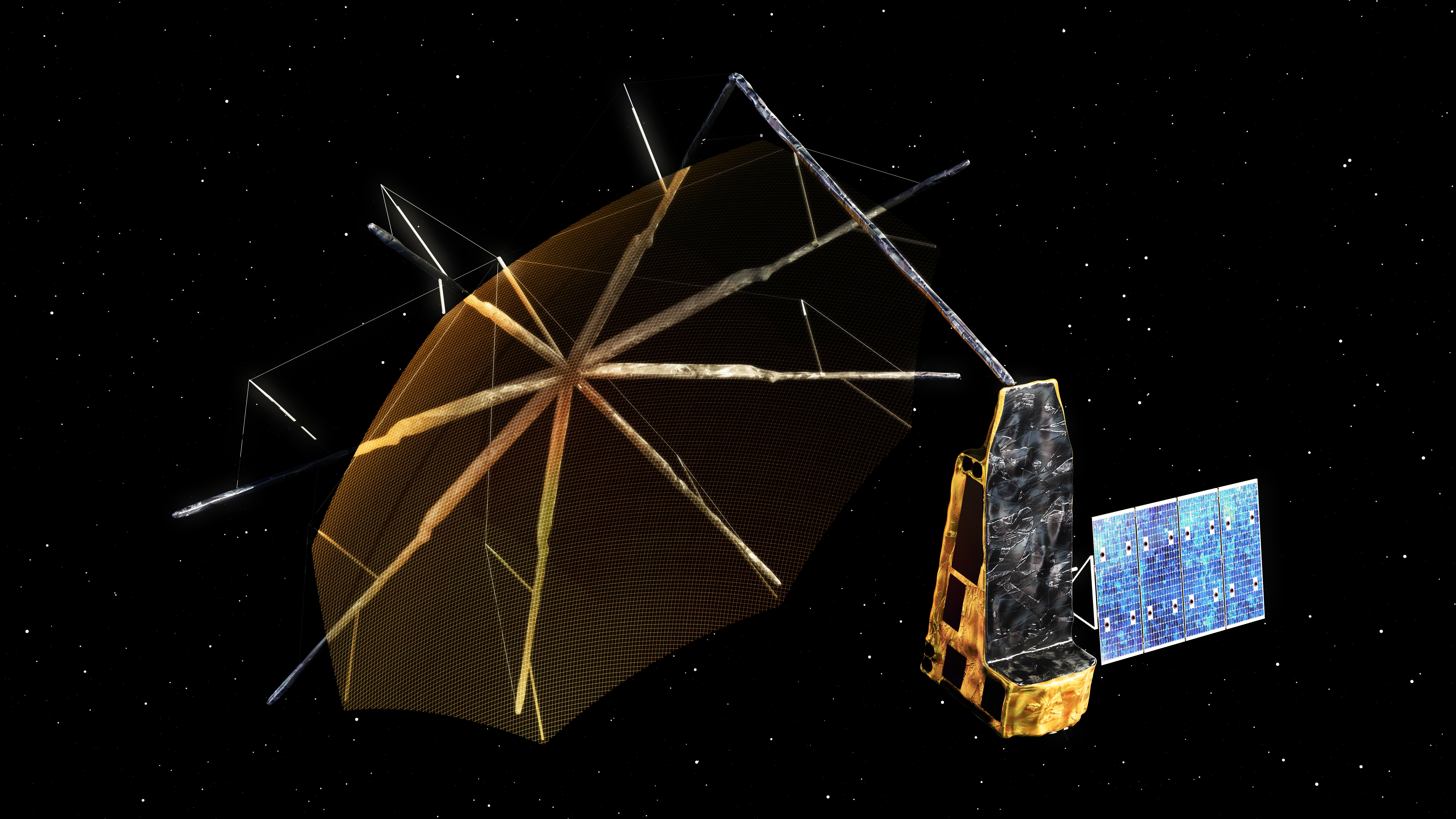
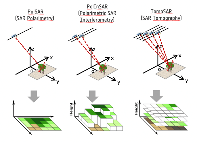 Illustration of BIOMASS observation modes.